
In support of the United States' goal to deploy 30 gigawatts of offshore wind energy by 2030, the Department of Energy (DOE) Wind Technologies Office recently announced $15 million for five projects, co-funded by the Bureau of Ocean Energy Management (BOEM), that will provide critical environmental and wildlife data to aid offshore wind development. As part of that effort, the Marine Mammal Institute (MMI) at Oregon State University (OSU) began the MOSAIC (Marine Offshore Species Assessments to Inform Clean energy) project to conduct environmental research to inform the development of offshore wind energy along the U.S. Pacific Coast.
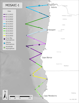
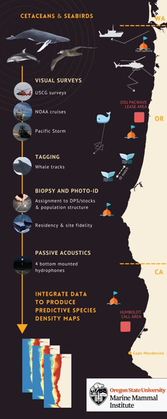
Working over a four-year period from June 2022 to May 2026, MMI's MOSAIC project will collect data on cetaceans and seabirds in waters of the continental shelf and slope (to 3,000 m water depth) of Northern California and Oregon. Measurements will consist of two years of visual surveys for cetaceans and seabirds (spring, summer, and fall; Figure 1); two summer/fall seasons to collect cetacean photo-identification data; biopsy samples; and place satellite tags on large whales; and 3.5 years of cetacean passive acoustic monitoring (Figure 2). This data will be analyzed during the last two years of the project.
The goals of MOSAIC are to quantify cetacean and seabird distribution and density throughout the study area at a fine spatial and temporal (seasonally explicit) scale; behavior and residence patterns for baleen whales in the study area; stock identification for humpback whales; and calling rates for blue whales. MMI will also develop spatially and temporally explicit Species Distribution Models (SDMs) to produce predictive density maps for all species in the study area. Information gathered through this project will be used to produce predictive density and distribution maps of species presence in potential wind energy development areas.
The maps produced will inform siting of floating offshore wind energy platforms by clarifying spatially and temporally explicit patterns in distribution and abundance (cetaceans and seabirds), stock structure, and residence patterns (cetaceans).
The analytical component of MMI's MOSAIC project will involve the development of new ensemble methods to integrate disparate datasets together to produce species distribution models and resulting density maps that are more robust because of the diversity and power of multiple datasets. These methods can be transferable to similar projects on the U.S. Pacific Coast, Atlantic Coast, and around the world.
The U.S. Pacific Coast is expecting significant offshore wind development and has a relatively un-developed coastline; so, it is important to take stock of natural resources to protect them. The data records and derived product of this project will become important decision support tools for local, state, and federal regulatory agencies and other stakeholders seeking to mitigate exposure to anthropogenic risks. The predictive density maps generated by this project's species distribution models will provide critical information toward responsible siting and permitting of offshore wind energy development and for assessing its impact on marine life.